UW Interactive Data Lab
papers
AltGeoViz: Facilitating Accessible Geovisualization
Chu Li, Rock Yuren Pang, Ather Sharif, Arnavi Chheda-Kothary, Jeffrey Heer, Jon E. Froehlich.
Proc. IEEE VIS Short Papers, 2024
Proc. IEEE VIS Short Papers, 2024
Abstract
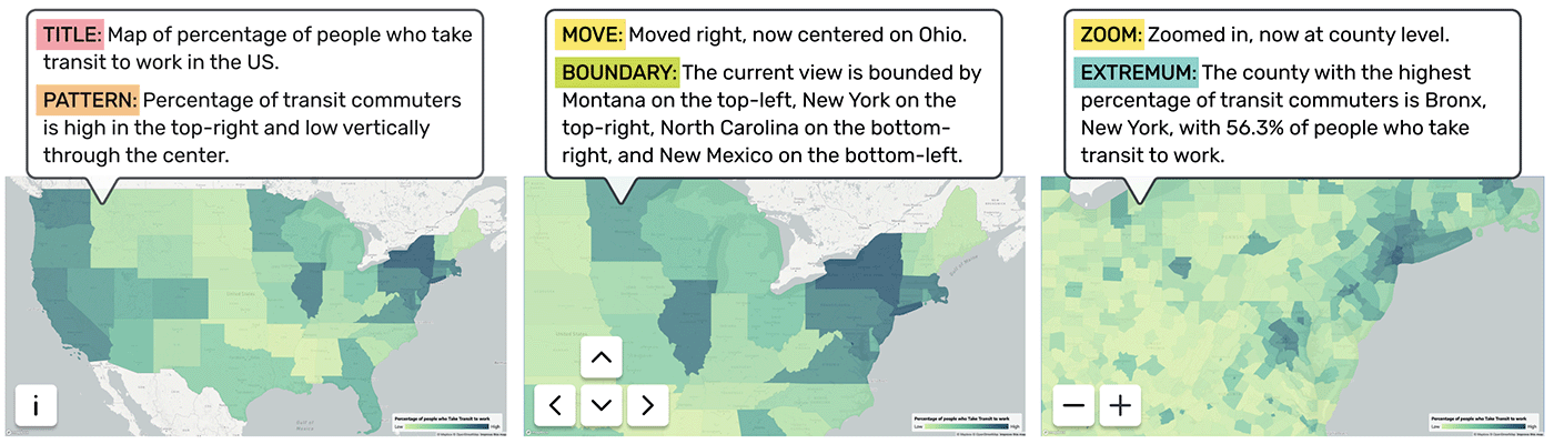
Geovisualizations are powerful tools for exploratory spatial analysis, enabling sighted users to discern patterns, trends, and relationships within geographic data. However, these visual tools have remained largely inaccessible to screen-reader users. We present AltGeoViz, a new system we designed to facilitate geovisualization exploration for these users. AltGeoViz dynamically generates alt-text descriptions based on the user's current map view, providing summaries of spatial patterns and descriptive statistics. In a study of five screen-reader users, we found that AltGeoViz enabled them to interact with geovisualizations in previously infeasible ways. Participants demonstrated a clear understanding of data summaries and their location context, and they could synthesize spatial understandings of their explorations. Moreover, we identified key areas for improvement, such as the addition of intuitive spatial navigation controls and comparative analysis features.
BibTeX
@inproceedings{2024-altgeoviz,
  title = {AltGeoViz: Facilitating Accessible Geovisualization},
  author = {Li, Chu AND Pang, Rock AND Sharif, Ather AND Chheda-Kothary, Arnavi AND Heer, Jeffrey AND Froehlich, Jon},
  booktitle = {Proc. IEEE VIS Short Papers},
  year = {2024},
  url = {https://idl.uw.edu/papers/altgeoviz},
  doi = {10.48550/arXiv.2406.13853}
}